Recently, Hannah and I went to Seoul (Hannah is writing about that as I sit here writing about my thingy) and we were able to get a spot with the USO for a tour of the DMZ (De-Militarized Zone). For those that don't know about it, I'm about to lay some history on y'all:

Just to prove we were there. Behind us, a South Korean soldier and a North Korean soldier glare at each other across the border (the North Korean is a dot behind Hannah's head).
Following WWII and the defeat of the Empire of Japan, there were quite a few negotiations going on regarding ownership of the Japanese territories that were annexed before and during the war, one of which was Korea. For reasons that seem to me unclear, the peninsula was divided neatly across 38 degrees north latitude (the 38th Parallel) with the Soviet Union taking custodianship of the northern half and the United States of the south. ((Wikipedia says something about the USSR invading Manchuria and occupying northern Korea around the time of the negotiations, but I think something is missing here)). Anyway, the goal was to introduce a democratic government in Korea with the eventual goal of reunification.

Of note here are the 38th parallel (border pre-conflict), the Military Demarcation Line (border after conflict- present), DMZ buffer zone, and locations of 1st, 2nd, 3rd, and 4th Infiltration Tunnels (covered in some detail later on in the post)

Come and say that over HERE, mother f***er! (Not my photo!)
Anyway, our tour begins at Camp Kim USO in Seoul. Hannah and I shook ourselves out of bed at the hanok around 5:50AM to arrive at the USO at 7AM. The bus departed promptly at 7:30AM on the dot. If you were but a moment too late, your 96,000won deposit (about 85$ CDN) counted for nothing. We headed northward out of the big city lights and into the country. After about an hour, we arrived at a massive gate with massive soldiers and massive roadblocks. Unfortunately, pictures were/are pretty scarce after this point because there were many conditions and orders in effect, so all I can do is write about it. I'm guessing they don't want the North to get ahold of any info regarding their blockades and traps. That and, well, they would confiscate my camera if they caught me being a dick about it, so I decided to be a good boy! Anyway, this intimidating barrier would mark the beginning of the South Korean DMZ.
After this gate was an area of fairly dense deciduous forest and wide trenches. We were told that this was an active minefield used to dissuade intruders. We were also told that, on occasion, animals set them off! How much would THAT suck?? We also came across electric fences and tank traps which, apparently, span all the way across the peninsula! We were not told to avoid straying from the group at any point, but it did not need to be said.
After a 20 minute drive through various checkpoints and waiting stations, we arrived at Camp Bonifas- so named after an American Captain killed during the 1976 axe incident (more on that later). We were given a very short briefing and were required to sign waivers that stated, in essence, that if we were injured, shot, incinerated, blown up, dismembered, decapitated, eviscerated, eye-gouged, stabbed, poisoned, or got any little boo-boos of any sort, the army was not responsible. We were, in essence, entering a war zone.
Following the briefing, we loaded up in a military-owned transit bus and headed to the first (and possibly most-fascinating) stop on our tour: the border crossing at Panmunjom. It was during our departure from this base that I caught my first glimpse of a MASSIVE North Korean flag just over the treeline. Everyone on the bus hushed themselves in awe and my heart sank about an inch. We were not in Kansas anymore.

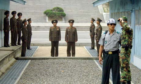
Panmunjom used to be the name of a small village just south of this area, but now comes to represent the crossing and the soldiers barracks at the area where we would get as close to North Korea as we could without being arrested or killed. In this area, South Korean guards in full uniform stood like statues glaring into the North and US Solders walked about as backup. The blue buildings along the border belong to UN forces and the grey ones belong to the North.

There were multiple South Korean guards protecting us.

Side note: this fellow is standing this way so that, if bullets start to fly, at least half of his body is protected by the building. The North Koreans do this too when they're posturing.
Across the border, we could see a lone North Korean guard standing at his post. I was surprised by how young, thin, and frail the guy looked. On occasion, he would take out a camera and take pictures of us. I fail to see why, though, as there were quite possibly hundreds of video cameras mounted on both sides of the border looking in all directions.

I hate "tour day"! (Not my photo, unfortunately)
We were ushered into a bunker-like room at the border. In this room were two towering South Korean "stone soldiers" and a long table with a line of microphones going down the middle. We were told that the mics are ALWAYS on and that they are monitored constantly (a potential contender for most boring job EVER). The Six-Party talks (South Korea, North Korea, USA, Japan, Russia, and China) occur at these tables during negotiations and the line down the middle of the table follows the exact border between the two countries. This means that, during the time this photo was taken, I was standing in North Korean soil!


This photo is just to prove that I was, in fact, "in" North Korea for 2 minutes.
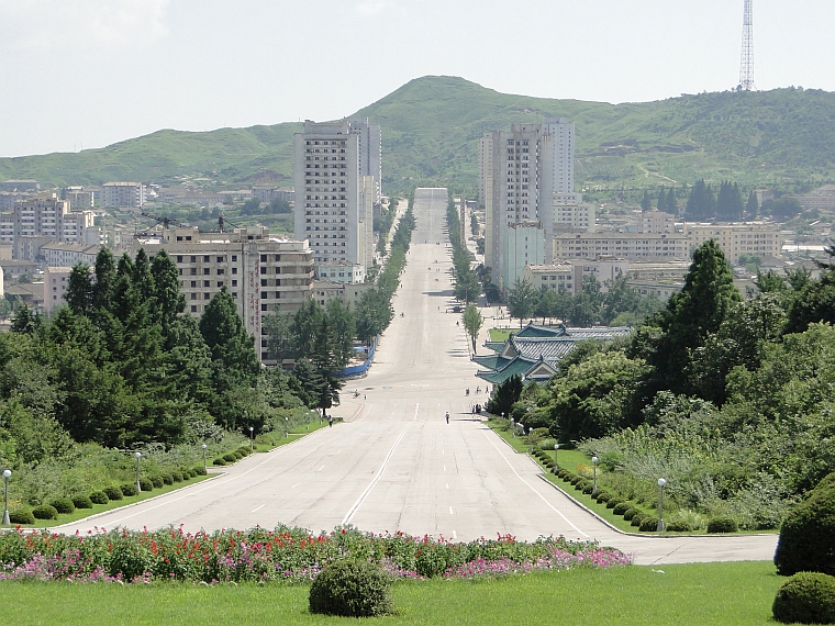
We were ushered out of this building after a fairly short time and taken to our next spot: a guard post overlooking the so-called "Propaganda Village" of Kijong-dong.

Click to enlarge. This one really can't be scrolled past.
I have to say, that this particular spot was absolutely eerie. In this place, the vastness of North Korea becomes almost overwhelming. What especially spooked me was not the guns, guards, razor wire, or even the city before us. What spooked me was the immensity of the North and how barren it was. The tree-line ends at the border and nothing but naked earth spans on into the distance. Even the immense snow-covered mountains were laid bare. It just looked cold and dead, yet hauntingly beautiful. We were taken to another site later, the Dorasan Observatory, were we got another broad glimpse of the North. though the view was not as unobstructed.
It reminded me a great deal of a photograph I saw in one of my biology textbooks. The border between Haiti and the Dominican Republic is incredibly stark. Whereas the Dominican side is lush tropical rainforest, the Haitian side has been cut down to the earth in attempt to glean any possible resources. Part of me wondered if the North Korean side was bare for surveillance reasons, or for economical reasons. Hannah tells me she heard that the trees have all been cut since North Korea has no oil and largely cannot trade for oil, so they need to burn wood for warmth.

Guess which side is the poorest nation in North America?
Anyway, not too far in the distance sat Kijong-Dong. In the middle of this impressive village was a massive, 160m-tall flagpole touting what is supposedly the largest flag in the world (dry weight, 300kg!). We caught it on an amazing day with a good breeze and 100% visibility. Our tour guide even remarked that she had never seen such good conditions for the tour.

The offending flagpole in question.
A funny story about the flag: for some time there has been a large flagpole in Kijong-dong to, in essence, advertise the 'greatness' of the North. However, in the South Korean DMZ there is a small farming village called Daesong-dong that erected a flagpole of rivaling size overlooking Kijong-dong. As it turns out, the South Korean flagpole was TALLER than the one on the North's side!

Daesong-dong, pictured above. We were actually not permitted to photograph the village, so this is from Google.
So, in the 1980's, the North retaliated by making an even BIGGER flag and adding several meters to the top of the pole, making it bigger than the South's side. This came to be known as the "Flagpole Wars".
The significance of the "Propaganda Village" made the ludicrous-seeming "Flagpole Wars" make sense, in a certain light. You see, Kijang-dong was made shortly after the Korean War at great expense to the government to appear great and wealthy to potential South Korean defectors. The thing is, though, that this entire village is EMPTY, save for a handful of soldiers posted near the border. It was created only to produce the illusion of wealth and prosperity. The American soldier giving us the tour told us that there are some buildings in the village that are simply shells: buildings with windows and doors merely painted on to give the appearance of habitation from a distance. There were even several loudspeakers mounted around the area blaring pro-Northern and anti-Western propaganda to the South in attempt to encourage defection (currently there are cameras in their places since the whole propaganda thing did not work at all). The whole flagpole thing was a matter of "saving face" and posturing.
A few kilometers away is the Kaesong joint industrial zone: named after the capital city of the Koryeo dynasty (918-1392 AD), which was on that spot. The Kaesong can be viewed as both a promising and depressing development between the two Koreas. Promising, in the sense that it is a jointly-owned (North-owned, South run) industrial area on the border that represents collaboration between the two Koreas. Depressing, in the sense that the 45,000 or so North Korean workers make pitiful wages (one source wrote 1/4 of the minimum CHINESE wage!) to make low-end products in competition with China. The 800 South Korean staff, being management, likely receive wages well above average, given the volatile nature of their jobs. Regardless, since its creation 10 years ago (established in 2002), it has been a growing source of diplomacy and economic cooperation between the Koreas- essentially a foot-in-the-door for reunification. Below is a picture from Google as, once again, I was not able to get a picture of the site.
Not shown are the factories and the highway coming from South Korea (Not my photo)


We made a very brief rolling-stop (we did not leave the bus) toward the border again to see two structures: the "Bridge of No Return" and the 1976 Axe Murder memorial. The "Bridge of No Return" is a rather unremarkable concrete bridge running between the Koreas across the border. After the Korean War this bridge served to transport prisoners of war both ways across the border. Panmunjom now serves this purpose and the bridge remains largely as a historical reminder (though a guard post is directly next to it)

The Axe Murder Memorial, however, deserves more than a one-liner. You see, prior to 1976 the Panmunjom JSA (Joint Security Area) that we visited was used by both Northern and Southern forces simultaneously. This is to say that this area was bonafide no-mans-land and both sides had guard posts on both sides of the border. This all changed in 1976. You see, at the extreme end of the JSA was a UN guard post surrounded by North Korean posts. This was all the more worrisome because the view of this post was obscured from the other UN posts by a large poplar tree nearby. To correct this, a handful of American soldiers were dispatched to remove the tree. Upon arrival, they were met by 26 North Korean soldiers who were less than impressed by the mission (our tour guide says that the "enemy" refused to allow the felling of the tree since it was "planted by Kim Il Sung himself". Upon evidence that the tree was, in fact, OLDER than Kim Il Sung himself, the northerners cited "supernatural forces"). Anyway, the Americans did little more than chop off a branch before the enemy attacked and overwhelmed them. The North Koreans were even able to kill two of the Americans by turning their own axes against them. One of those slain was Captain Arthur Bonifas, for whom the UN DMZ camp is named. Following this aggressive act, the borderline was enforced more rigidly and North Korean guard posts were removed from the South's JSA half, and vice-versa. The memorial is situated exactly where the poplar tree once stood.

A model of the Axe Incident found in one of the museums at the DMZ
After the Axe Murder Incident, the US, South Korean, and UN forces collaborated on "Operation Paul Bunyan": quite possibly the most expensive tree trimming in history. In a decisive and concerted attempt to remove the offending tree, a massive force of UNC soldiers (Wikipedia states around 800), backed up with air patrols, heavily-armoured vehicles, and attack helicopters were successfully able to remove most of the tree from the site. They even moved the aircraft carrier USS Midway near the site "just in case". A frigging aircraft carrier was used in the effort to chop down a tree. Epic. Anyway, the mission took about 45 minutes to accomplish, leaving just a stump on the spot. The stump was later replaced with the memorial in, what I can only assume, was a less dramatic show-of-force.


The Axe Incident Memorial

Click it to see the inscription, if you're interested.
We also stopped at a site that was simultaneously comical and terrifying: the Third Infiltration Tunnel. You see, there have been four different tunnels discovered running from the North under the DMZ (located on the map of the DMZ at the beginning of the post). Of these, two are open for public viewing and the other two are heavily guarded. Discovered in 1976 with the help of a North Korean defector, this was the third of the four discovered; however, there are believed to be several more. Now, this is terrifying for obvious reasons, as this 1600m-long tunnel represents a concerted attempt by the North to invade the South near Seoul. It is also quite claustrophobic: reaching only about 1.5m tall and 2m wide. However, it is also quite comical as this linear, south-going tunnel was later claimed to be a "coal mine" when the North were questioned. Retreating soldiers even painted patches of the granite walls with coal dust in an attempt to disguise it! This is very funny since there is no indication that there would be anything but hard granite in the area and since most of the "coal patches" were not exactly artfully done.
The tunnel has been sealed at the border using a triple barricade of thick concrete, explosives, and a simple "water trap" designed to flood the tunnel when a wall is breached. There is a plaque of this system posted outside the tunnel, so I assume that the South Koreans won't mind if I post it here:

This is actually really clever!
The way they discovered this tunnel was ingenious in its simplicity. Following tips from the North Korean defector, the South inserted a series of pressurized water pipes deep into the ground near the site. When the North's mine touched a pipe, a jet of water would spew into the air above ground. The South then waited for the tunnel to touch a second pipe to calibrate for direction, and then dug down 350m to intercept the tunnel. That must have been an awkward encounter. Other discoveries were less awkward and more aggressive: for example the First Infiltration Tunnel was discovered from steam rising through the ground. Investigating units were assaulted with gunfire and explosives. Upon breaching the first tunnel, weapons stores and soldiers baracks were discovered underground. I think that, because of the complexity of this tunnel as well as its proximity to Seoul, the First Infiltration Tunnel is not available for public viewing.
At this point, I would like to point out something that both Hannah and I found more-than-a-little distasteful. Next to the Third Tunnel there was a small museum with a few wartime relics and a movie theatre that we were REQUIRED to sit in. In this theatre, we were shown a 10 minute propaganda movie not only extolling the "goodness" of the DMZ, but outward demonization of the North, calling them "deceptive liars" and the like. We hear all too often about Northern propaganda and being force-fed thoughts in the Stalinist state, but I was shocked about just how thinly-veiled the propaganda was from the supposedly-free South! I guess it works both ways when it comes to a war of ideas, even if one side purports to allow freedom of thought.
**On a bio-nerd note, the DMZ is a bit of a fascinating place since many critically endangered creatures, including Korean deer (the size of dogs), a species of leopard, red-crowned cranes, several endangered birds, and even (possibly) Siberian tigers are known to live there due to minimal human activity! How they are able to survive the mine fields I will never know, but I suppose this is at least one way that the DMZ could be considered a "good" thing. There is talk of preserving the DMZ as a nature reserve after reunification, but I'm skeptical.**
Anyway, following this, we went to lunch (bulgogi!!!) and travelled to our last stop: the Dorasan Train Station. This train station was built within the last 10 years with hopes that it could be united with North Korean tracks during reunification. The structure is largely a symbolic structure with limited practical use (no trains come here- even from the South), but it represents the desire of the South to become whole again (ed. note: if this is true, they should REALLY consider editing that propaganda movie.). The station is very modern and fairly comfortable, though very empty and quiet. I felt bad for the soldiers posted here.


The eventual goal of a pan-Eurasian railway joined to the Trans-Siberian Railway through North Korea

.....aaaaaand our lunch, for those curious. I had quite a feed!
Also, here's something you don't see everyday:

All-and-all, it was a very busy 8 hours that was well worth the price. I will say once again that this was probably my most important experience in Korea to date as it is all to easy to forget that this is a divided nation that is, in essence, at war with itself. I feel that it is profoundly important for anyone living in Korea to visit this area to remind themselves that it's not just kimchi and cartoon animals here.
On a closing note, as I later would tell my students, in Canada and America, North Korea is basically a weird, crooked little corner of the earth somewhere "over there". It's something that warrants a minute-long block on the evening news every few weeks or, if something happens, maybe a news article in the paper. However, seeing the vastness of the land, the beauty of it and the sorrow seeping out of the landscape in person is quite a different thing entirely. To me, the place is no longer a "bunch of cultists" or a "backwards place 'over there'", it's a place that really deserves pity. This is not to say that it is a "good place", far from it!, but that it is a real place with real people in real trouble. It's too easy to forget that.
Just one more thing, the name of the update is not original. One of my hardcore gamer students, upon seeing my photo of Kijong-dong exclaimed, "OH! Red team!", which was amazingly awesome.
We forgot to post a comment when first read this. Wow, what a trip! You have a talent for painting images on pages with words. Ever thought of being an author? We've enjoyed ALL the stories you've posted this past year! Chuck & Rosemary
ReplyDelete